

![]()
Cody Wortham
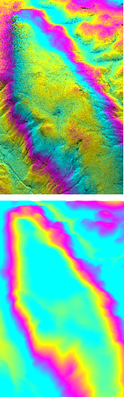 |
My research interests include processing techniques and deformation modeling for the UAVSAR (Uninhabited Aerial Vehicle Synthetic Aperture Radar). The UAVSAR is unique in that the airborne nature of this platform allows for repeat pass interferometry on a much shorter timescale than other orbiting systems. As a result, we can use the differential phase measurements to model and understand the sources of rapid, time varying deformation.
The figures on the left (Top: raw interferogram, Bottom: simulated phase) show some processing results, where we have simulated the topographic contribution to the differential phase by mapping the radar pixels directly to the latitude/longitude domain. This technique is in contrast to the traditional approach of solving for phase directly from the known DEM (Digital Elevation Map) heights. Our method avoids the use of irregular data interpolation and saves unnecessary computations. Currently, I am exploring methods to automate the modeling process. Physics dictates how volcanoes and earthquakes deform the surface of the earth (forward problem), but in general, there is no one correct way to solve the inverse problem. An accurate inversion requires careful analysis and geophysical insight. I plan to develop a set of techniques where, based on the deformation field, the computer can make intelligent decisions as to which model to use and how to select inversion parameters. |