California Levee Failures: 6000 BC to 2000 AD.

On Friday, January 17, two weeks
after the levee failure at Olivehurst, I flew over the flood
devastation at Olivehurst with Assemblyman Richter and his brother, Raymond. About one-half
mile south of the main levee breach we found an orchard pockmarked with sinkholes.

Close inspection showed that the boils were no more than an inch in diameter. However,
these seemingly innocuous features can rapidly grow to levee-threatening size. In this case
flood
fighters had averted the danger. Flying low over the orchard treetops I shot this picture of
two of these crater-like sinkholes
a hundred or so outside of the toe of the levee. There were dozens more scattered over this
orchard.

Later we visited the orchard
where these features were found. The televison crew from KCRA Sacramento did a special program
on the sinkholes.
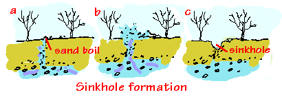
How do these features develop?
Partially developed sand boils create hollows beneath the ground surface. When the flood
recedes, sinkholes form above the cavities. The sinkholes are a good indication of where
active foundation erosion is present, and are an important sign of potential future failure.
Questions or Comments?