flood cnn::451
We focus here on a particular (and deadly) type of levee failure that is characteristic of California rivers.
These failures result as part ofan historical geographical sequence as shown on the
animation.
flood vtech:lf106j.gif:450

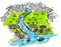
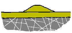
Rivers build their own natural levees and
eventually become higher than the valley floor. Levees have failed since the earliest of
times: during large floods even natural levees may overtop or breach in what is known as a
crevasse, flooding the adjoining lowlands.
flood geox:an103.gif:111
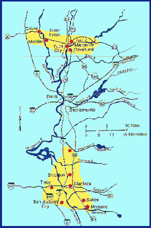
Note that in California levee failures take
place in certain areas. Can you tell why the pattern of levee failures of January 1997 is the
way it is? Hint: Most of the filures (hre and at many other sites in the world) occur at about
elevation 50 ft above sea level.
flood cnn:failmap.gif:447
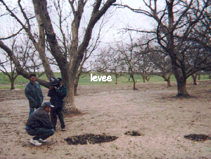
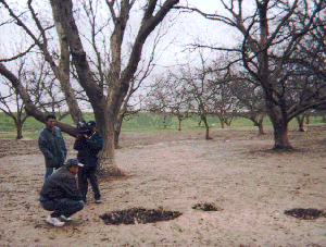
Certain danger signs precede levee failures.
Sand boils are especially ominous. Here is the remains of one sand boil, at Arboga, after the
1997 flood. Perhaps the ancient idea of flood waters rising from the deep is associated
with these features.
flood noah:crew.gif:13
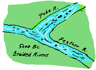
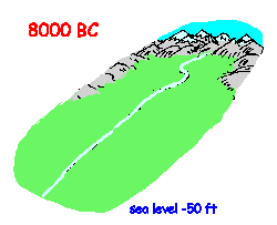
The history of sand boils and levee failures
begins at about 6000 BC: In those days when giants walked the earth the streams were fast
running and braided, with long straight gravelly stretches, much like the streams in mountain
valleys today. The gravels were highly pervious, that is good carriers of water, and are
still tapped as sources of water for farm and domestic wells.
flood geo:a1.gif:100
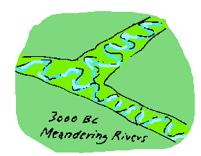
Then at about 3000 BC a combination of global events, including sudden climatic change, floods, and possibly meteor impact, shocked the rivers into a new type of flow.
Major rivers
throughout the world began to meander,
swinging back and forth in their channels.
flood geo:b1.gif:101
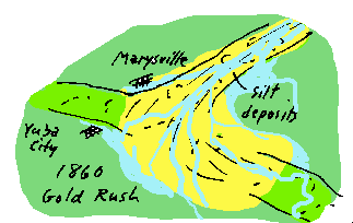
The next major trauma to affect the Yuba and other
Sierra streams was the
hydraulic gold mining in the 1860s. Giant hoses washed away mountainsides,
choking the river channels with golden silt.
flood hist1:d1.gif:99
In the late 19th century levees were built to confine the rivers to the center of their old channels. The lust for land replaced the greed for gold. The levee builders ignored the old river channels, hoping to confine the river. The old channels remained buried beneath the golden silt and the black fertile orchard lands.
Today, knowledge of the old ways of the river is the key to predicting the
fatal flaws in our attempts to control nature. The meanders of the rivers are the
failure hot spots.
flood hist1:e2.gif:98
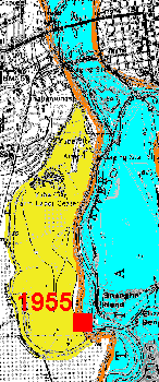
North of Sacramento, a classic levee failure in
1955 drowned dozens of people.
flood cnn:kd408.gif:425
Following the 1955 flood the area around Shanghai bend was partially repaired. Since then the area has been a favorite for land development, with over 150 new homes built there since 1989.
Flood insurance is not required, the realtors will tell you, though they don't mention the mandatory evacuations when the river rises. Life insurance isn't required, either, though it might be wise to have it. Without these long-term measures flood prone lands will continue under heavy development pressure (as here, where the site of the 1955 levee failure (28 fatalities) at Yuba City is for sale to developers. The levee has not been improved.)
Note that flood insurance is not required, the site being outside the levee and therefore protected against flooding. Ironically, the history in the Yuba City-Marysville area demostrates that the return period for extremely dangerous flooding arising from levee failure is close to 15 years. (1955, 1986, 1997)
Nonetheless, vast tracts of land are scheduled for development in these high-risk areas.
flood shang vtech:sale.gif:46
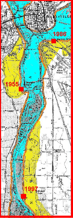
Consider point (a): If you knew about the 1955 and 1986 failures, could you suggest where a future failure might be?
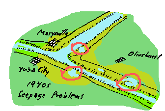
Notice how the levee extends well out into the floodplain (yellow) at the failure locations. This is a legacy of the "levee wars" of the late 19th century. Land owners hoped to push the river over into the other county. The situation became so unfriendly that levees were sabotaged by dynamiting.
These same areas have been subject to well-documented, flood-induced seepage (which damages
orchards) for decades.
flood geox vtech:usgs4.gif:359
The location of the next breakwas easy to
predict. What is less obvious is the pattern of events that led up to it.
flood cnn:kd420.gif:437

Sacramento itself is under severe threat of
levee failure.
flood cnn:failmapa.gif:449
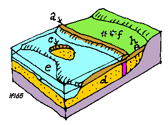
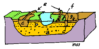
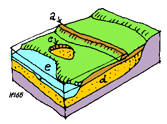
Floodwaters pass under levee (2), entering
previous substratum (d) either through river channel (e) or through man-made pit c. Resulting
pressure acts upward on topstratum (b) causing sand boils (f). Pressure may be relieved by
drains (h) or may be blocked by cutoff (g). However imperfect cutoff (as shown) still allows
pressure beneath land side.
flood cnn:lf165.gif:441
Sinkholes remaining on the land side of the
levee after the flood are evidence of sand boils, sign of impending failure since the time of
Noah.
flood cnn:crew.gif:446
The fact is that most levee failures have not been caused by overtopping; therefore the whole idea of the hydrologic 100 year flood does not lead to estimates of risk. In fact the levees near Marysville have failed disastrously trhee times since 1955-- a "return period of only about fifteen years!
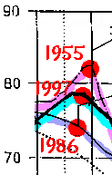
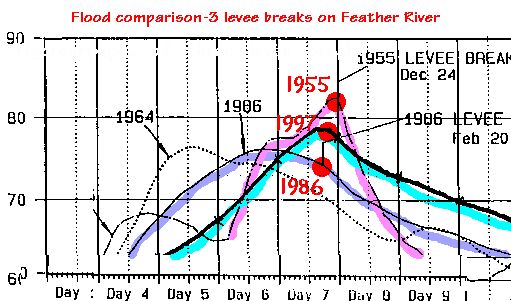
Investigators of the Feather River levee failure will be especially interested in comparing flood hydrographs for various past floods that have caused failures on the levees near Marysville and Yuba City.
Here we see a comparison of floods for 1955, 1986, and 1997. The levee-threatening rise in water shows a similar profile for each year. The time of levee failure is shown by the red dot.
Note that though the 1955 and 1997 breaks occurred while the water was still rising, the 1986 failure was some time after the floodwaters began to recede. This provides an important clue; namely, that the pressures causing failure lag behind the immediate flood pressures on the levee. In 1986 the failure was a day after the peak in flood, and many of the flood fighting efforts had been called off.
The levees were not overtopped. In each case, sand boils had been observed at the toe (or outside of the toe) of the levee before failure.
We can conclude from this that some time may elapse between pressure on the
levee and pressure at the boil. This lag tiome can be analyzed
using an engineering model.
flood hydro:peak1s.gif:20
But the purpose of these levees is not to create
riches for outside land speculators to expunge these remaining beautiful and agriculturally
productive areas through unplanned suburbanization. Properly conceived, they should be
maintained to enhance the scenic and agricultural character of the land and prevent disastrous
flooding of the urban lands that draw their historical and economic sustenance from the
productivity of the land.
flood cnn:sale.gif:440
Typical Mississippi River condition near
Natchez, Mississippi 100 miles up from coast. Pleistocene pervious deposits (a) are overlain
by 50 ft. Holocene sands (b) and clays (c). Levees (e) are vulnerable to failure at places
like (f) where pressure builds up in sands outside of levee, causing sand boils and uplift
pressures beneath levee.
flood cnn:lf163.gif:443
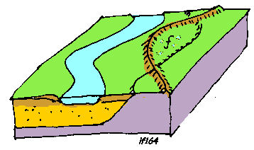
In California the equivalent condition (f)
develops where the levee is pushed out into the floodplain.
flood cnn:lf164.gif:442
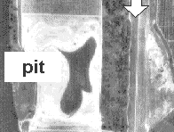
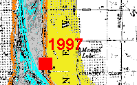
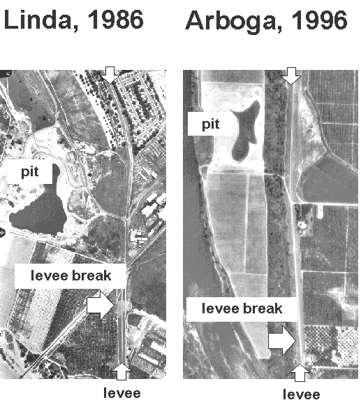
Here is visual comparison between the 1986 and 1997 levee failures and the location of pits dug in the floodplain near the levees. Both photographs are the same scale.
Artificial pits were present at both failure sites as shown in the photographs (same scale).
Pits are 1000 to 2000 ft. away from the failure points, in line with old channels that pass
beneath the levees.
flood mech4 vtech:lindas.gif:28
Soil profile at site of Arboga break, showing a "mitigation pond" and slurry cutoff wall (Corps of Engineers).
The slurry wall is meant to block underground seepage (see animation).
flood cnn:lf165.gif:444
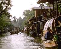
A near-disastrous experience in 1963 in
Thailand led me to a source of wisdom: the famous engineer P.T. Bennett. Bennett showed me
how tampering with the upstream natural blanket could lead to disaster.
flood cnn:img0046s.jpg:427
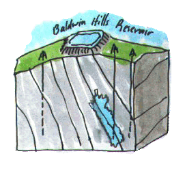
In 1970, I studied the failure of Los Angeles
Baldwin Hills Reservoir which burst its artificial lining on a hot Saturday afternoon in 1963.
With characteristically origined insight my geologist partner Douglas Hamilton related the
failure to oil field operations. Standard Oil and their friends at the State Division of Oil
and Gas were not happy with these results, which established that if you pricked too many
holes in the earth, there was trouble. Our discovery was featured on the cover of Science
Magazine in 1970. Our consulting business took off.
flood lpp3:lpp3.gif:105

Seepage under the reservoir led to a final
collapse.
flood lpp3:Baldwin.gif:35

As always in my generation, there was a rush to
fix any problem with chemicals and injections. Whatever got in the way was dispatched with
those harnessed slaves of the anoxic underworld, DDT and asphalt.
flood cnn:lf103.gif:418
Hence our propensity for grouted walls --
artificial chemical barriers which are meant to keep the water where we command, like King
Kong in his cage or the Vietnamese in the North.
flood cnn:kd404s.gif:421

Abstract of AEG flood talk
Understanding the geology of lower valleys at about 5000-3000 BC has been an enterprise of
interest to religious enthusiasts and archaeologists for some years. But this same knowledge
is useful in understanding the mechanics of levee failures and flooding as was shown by Fiske
and others on the Mississippi in the 1940s. I attempt in this tour from Moss Landing to
Mesopotamia to Marysville to apply a similar approach to predicting the cause and impact of
California flooding. Results raise questions about the assumptions of both engineers and
ecologists who have been responsible for management of California's flood control facilities.
Dick Meehan has engineering degrees from M.I.T. and Imperial College,
University of London. Following service with the U.S. Army Corps of
Engineers he began designing dams and levees in Southeast Asia and South
America in the early 1960s. He wrote the book "The Atom and the Fault" and
has taught at Stanford University
for the past twenty five years.
flood cnn:rlmsk.jpg:321
Questions or Comments?